Quayside (The Key)
Quayside (The Key)
HER Number
1596
District
Newcastle
Site Name
Quayside (The Key)
Place
Newcastle
Map Sheet
NZ26SE
Class
Maritime
Site Type: Broad
Landing Point
Site Type: Specific
Quay
General Period
MEDIEVAL
Specific Period
Medieval 1066 to 1540
Form of Evidence
Documentary Evidence
Description
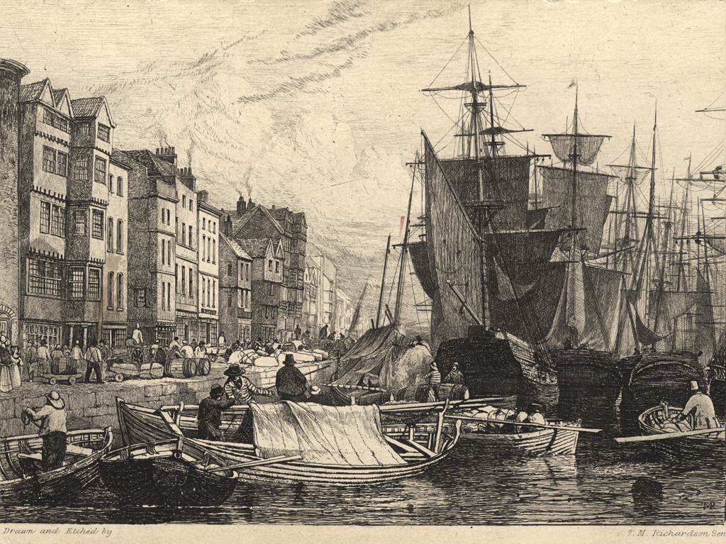
Documentary evidence suggests that the waterfront was not fully developed until the late 13th century or 14th century. There is archaeological evidence to suggest that reclamation was necessary before the Quayside could be laid out in its present form. The Quayside had buildings on the north side, but was, obviously, open to the river on the south side. There were no minor streets or chares running off the Quayside before 1376, although the word "Key" is used four times up to 1366. There are three pieces of evidence which seem to show that the Quayside as a roadway was a construction of the late 14th century - a Royal galley was launched from the mouth of the Pandon Burn in 1294, in 1342 a grant was made of land from Fishergate to the "ground-ebb of the Tyne" and in 1366 a messuage was described as lying on the Key. This may not indicate a continuous quay along the waterfront, but perhaps quays or staiths at the end of the chares. By 1376 William de Galway acquired a burgage "near the Keyside". The Quayside is referred to as "The King's Highway". How it was constructed is not known (borehole evidence show that ground has been deliberately raised by infilling up to 6 metres deep), but until the Quayside existed the town wall could not be built from Sand Gate to Sandhill (HER 1566). Bourne says that there were gates in the town wall through which masters and seamen could go to and fro from their ships. In 1616 only two of these gates were left open during the night, and these were manned, to prevent people throwing rubbish into the river. The Quayside is named "The Key on Hutton's map of 1770 with a low crane opposite Broad Chare and a high crane at the guildhall. Bourne describes a crane on the Quayside (a safe station for ships where they lie free and secure from the dangers of wind and water) for unloading wines, flax and other heavy goods. The Customs House was at the west end of the Quayside. He goes on to say that this long wharf is built upon sand and that the key extends in length from east to west 103 Rods. The street was mostly inhabited by merchants, hostmen, brewers and those involved in the coal trade etc. There were many taverns, ale-houses and coffee houses. By 19th century the Newcastle quays extended for a length of about 4,620 feetalong the north bank of the River Tyne, from the swing bridge, eastward to the mouth of the Ouseburn. In about 1840 a section of quay was erected by Mr. Anderson, the then river engineer to the Corporation. A portion of this quay, which was built in front of an older one, still remains. Prior to 1866 the quays extended from the old Tyne Bridge to the east end of Rotterdam Wharf (east of Swire). The extension of the quays eastward from Rotterdam Wharf was commenced in 1866, and by 1874 they had been extended to the Ouseburn. The 19th century quay wallsand bollards are listed grade 2.
Easting
425180
Northing
563780
Grid Reference
NZ425180563780
Sources
<< HER 1596 >> A. Scott, 1894, Deep Water Quays, Newcastle upon Tyne Institute of Civil Engineers Article; I. Ayris, 1997, A City of Palaces; W. Collard and M. Ross, 1842, Architectural and Picturesque Views in Newcastle upon Tyne, pp 26-27; B. Harbottle and P.Clack, 1976, Newcastle upon Tyne: Archaeology and Development, in D.W. Harding (ed), 1976, Archaeology in the North; H. Bourne, 1736, The History of Newcastle upon Tyne, p 133; G. McCombie and C. O'Brien, 1993, Newcastle Quayside Archaeological Project, Phase I report; Malcolm L Scaife, 1974, Newcastle Old and New; Grace McCombie, 2009, Newcastle and Gateshead - Pevsner Architectural Guide, pp. 120-2; Barbara Harbottle, 2009, The Medieval Archaeology of Newcastle in Diana Newton and AJ Pollard (eds), 2009, Newcastle and Gateshead before 1700, pages 31-32; Newcastle upon Tyne City Libraries & Arts, 1984, Gone…But not Forgotten 7 - Shops and Shopping, 10 and 16